Hi All,
It is time for a quick, or maybe not so quick, catch up. The good news is there will be lots of pictures.
When last I posted we had crossed through Four Corners and gone into Arizona. Our campground in Arizona was in Page. Here are some pictures from our first couple of days in Page.
 |
| The Glen Canyon Dam. The other side is Lake Powell |
 |
| The Colorado River as it heads downstream from Lake Powell. |
 |
| It's a long way down to the river! |
 |
| A bit of Lake Powell. A very small bit. That boat is a 40 - 45 foot houseboat. |
 |
| We enjoyed a Ranger guided hike out to a hanging garden in the desert. You can barely see Lake Powell in the distance. |
 |
| The scenery is stark but stunning. |
 |
| Rainwater permeates through the sandstone until it reaches a less permeable layer and then seeps out. In this case under a ledge where ferns grow because they are protected from the harsh sun. |
 |
| From the hanging garden as the sun gets lower in the sky. |
 |
| It's not a great picture of us but a pretty nice sunset. |
The last morning in Page (for this visit) we took a tour of Antelope Canyon. There are several companies that offer tours, we used "Ken's" and were very happy with the choice. Our guide, Tim, was Navajo and also a photographer. He helped everyone, no matter what phone or camera you had, to set up for the best shots. Here are pictures from inside Lower Antelope Canyon.
 |
| You climb down into the canyon which is pretty narrow in most places. |
 |
| All of the pictures are taken looking up from the floor of the canyon |
 |
| Water has formed some pretty interesting shapes over millions of years |
After our morning in Antelope Canyon we hooked up to the trailer and headed north to Utah. Our campground in Utah was pretty much right in the middle between Bryce Canyon National Park and Zion National Park. But first we went to Cedar Breaks National Monument.
 |
| At Cedar Breaks we took a hike to "Alpine Pond" This is the view along the way |
 |
| And this is Alpine Pond! |
 |
| Going further down the trail we saw some Aspens that had turned gold. |
 |
| I think I've already used "stunning" in this post but I'm wanting to again. |
 |
| An interesting tree trunk. At least I thought so. |
 |
| Heading back through the Aspens. |
 |
| The view from one on the many scenic overlooks. |
 |
| Along the road as we are leaving Cedar Breaks. |
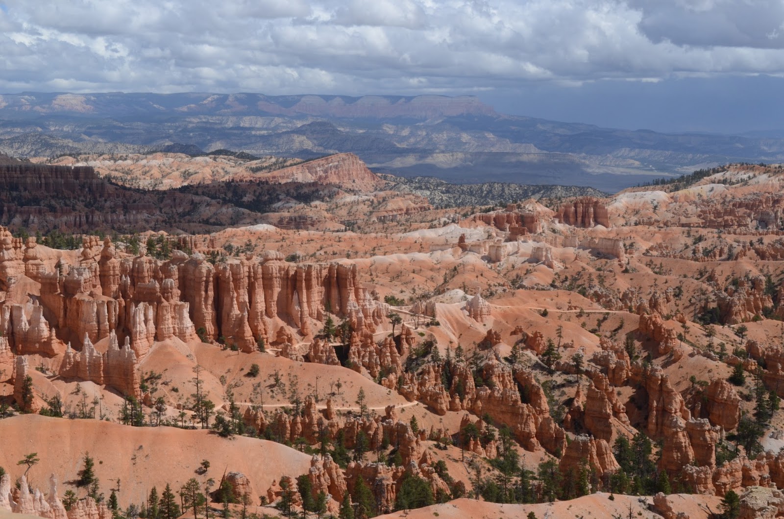
The next day we went to Bryce Canyon but we went through Red Canyon to get there. These first pictures are in Red Canyon.
 |
| Driving through Red Canyon you go through two tunnels that are close enough that you could stop between them and get to get a picture of both arches. Here's the one we just went through. |
 |
| And here's the next one, just ahead of us. |
On to Bryce Canyon!
 |
| Native American legend has it that Bad People lived in the canyon. They were so bad that the Coyote turned them into stone to stand here forever. |
 |
| There must have been a lot of bad people. |
 |
| Notice the ants (people) walking around on the floor of the canyon. Lower right. |
After these pictures we moved to a scenic overlook to have a sandwich. While we were eating we heard two bangs. A woman had pulled out of the parking lot without seeing a car coming down the hill. After the oncoming car hit her it swerved into the parking lot and hit two other cars. Nobody was hurt but it caused a mess for a couple of hours. The car that had been coming down the hill was occupied by a couple from the UK. As there car was not drivable, we gave them a ride to their hotel and then in search of another rental car.
The next day we went to Zion National Park. It was our least favorite but that isn't to say it wasn't beautiful.
 |
| Checkerboard Mesa |
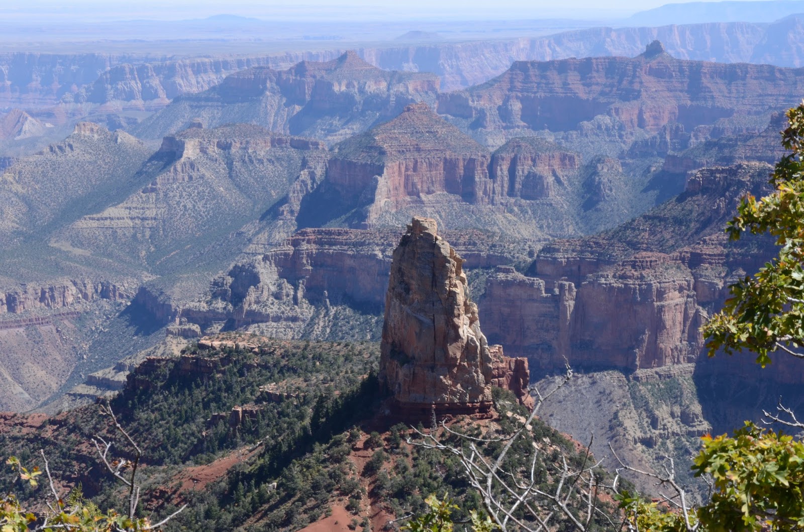
From our campground in Utah we visited the North Rim of the Grand Canyon. Susan hadn't been to the North Rim and I had never been to the Grand Canyon.
 |
| The North Rim is 1,000 feet higher in elevation than the South Rim but the steep canyon walls are on the south side. |
On Thursday, September 15, we left Utah and headed back to Page for another couple of days. On Friday we rented a boat for the day and toured Lake Powell by water. We saw a fraction of the lake in 8 hours. Lake Powell has 1,960 miles of shoreline. You could stay there all week and not see all of it.
 |
| The water is currently 479.6 feet deep at the dam. |
 |
| The white "bathtub ring" is approximately 80 - 100 feet tall. To give you some scale, that boat is 26 - 28 feet long. |
 |
| The lake is 52% full. Lake Powell began filling in 1963. The first time it was full was in 1980. There are currently 4,200,885,420,657 gallons of water in the lake. |
Saturday morning we made a quick (and early) stop at Horseshoe Bend, where the Colorado River makes a 270 degree turn. The sun needed to be higher to get rid of the shadows but the real issue is just how close do you want to get to the edge to get a picture. This will have to do.
 |
And this was taken by Susan, who is not the wimp I am when it comes to heights.
|
Sunday we moved to a campground in Valle, Arizona, just south of the South Rim of the Grand Canyon. Susan is right, it's prettier than the North Rim.
 |
| That's me, leaning against the wall. Pay no attention to the fact there is another 15 feet from the wall to the edge of the cliff |
 |
| We went back for the sunset and are we glad we did. |
That's all for now! Take care.
Brian