Monday, June 12, 2017

Fort Saint John to Watson Lake

Hi All,
Welcome to our 150th post!

Here's the route covered by this post...


We left Fort Saint John on Saturday, June 10 and drove to Fort Nelson. What does it look like to drive the Alaskan Highway? Here are a few pictures.


Our first Stone Sheep sighting

It's so cool to see waterfalls all along the road

On Sunday we drove to Muncho Lake where we stayed at a BC Provincial Park right on the lake. It was gorgeous. The weather didn't cooperate but we were still able to get a few good pictures.

Yes, that really is the color of the water

The view up the lake from our campsite

The view the opposite direction
From Muncho Lake we drove to Watson Lake in the Yukon Territory. We finally got pictures of black bears. It's tougher than you might think. So far Susan has identified a dead tree, a stump, a culvert and a rock as elk, moose, bear and a deer.

Baby Bear sitting up on a rise above the highway

Momma Bear eating down next to the highway.

A herd of wild Bison along the road
They didn't seem to be bothered by the cars driving past.
Of course we were crawling by in order to get pictures.

Even the babies didn't mind
A first for both of us

At the Visitor's Center in Watson Lake there is a signpost forest. There are currently over 83,000 signs in the forest. We added another one.


It has been interesting to note sunrise and sunset times as we move north and west. In Fort Nelson sunrise was at 4:01 AM while sunset was at 10:19 PM. In Watson Lake today, sunrise is at 4:11 AM and sunset is at 10:58 PM. We have to artificially create an earlier sunset and later sunrise. Remember we're old.  We can't sleep much when the sun is up and we sure can't operate on 5 hours of sleep. At 9:00 in the evening we pull the shades down on all the windows. Around 9:30 or 10:00 we put the blackout shades up. This will only work when we're inside at that time but it's been cold and rainy the last few days so it hasn't been an issue.

That's it for now. Take care.
Brian


Friday, June 9, 2017

Prince George to Fort Saint John

Hi All,
On June 7 we left Prince George and drove to Chetwynd and then Dawson Creek. Along the way we saw our first moose and another bear, both as we sped by at 100 kph so once again no pictures. I have pictures, just not of a bear or a moose. Here are a few from our campground outside Prince George.

Lupines, but they almost look like Texas Bluebonnets

This might pass for an Indian Paintbrush, but we don't think it is

At a rest stop north of Prince George, some of the biggest dandelions I've ever seen

The route map later will show it a bit differently but we drove through Chetwynd, took a few pictures, and then went on to Walmart in Dawson Creek  .Chetwynd is home to an international chainsaw carving contest so we went back the next day to watch. All through town are carvings that have come from the various years. Here are some we liked though I would say there are easily 40 around town.


 It was pretty amazing to watch live. There were twelve artists competing.


One guy from Japan

Each contestant started with a log of this size

Look at all those chainsaws

A lady from England was also competing
We wanted to go back by this morning and see how things looked after a full day of work but the weather turned cool and rainy so we headed back to Dawson City and then on to Fort Saint John.

Dawson City is the start of the Alaska Highway. It was built in 1942 - 1944 by the US Army Corp of Engineers purely for military purposes. The US military needed a reliable way to get people and equipment to Alaska in the aftermath of the attack on Pearl Harbor and our entry into World War II. At the time it was called the AlCan Highway but since 1948 when the general public has been able to use it the name changed to the Alaska Highway. Over the years as improvements have been made the original 1,523 miles has been shortened by 35 miles. In the 1970's Canada converted to the metric system and mile posts were replaced with kilometer posts. But some historic mile posts remain and many businesses are know by the mile post where they sit. It can be a bit confusing figuring out where something is because the mile posts were set for the full 1,523 miles. Changes to the road and conversion to the metric system have made it impossible to do a simple math calculation to figure out how far until you reach your destination.


Sculpture of the beginning survey

This sign commemorates the 50th anniversary of the Alaska Highway. Just so happens we'll be driving it on its 75th anniversary

Between Dawson Creek and Fort Saint John we took a small detour that takes you across a bridge that is no longer on the Alaska Highway due to those aforementioned changes. It is a curved bridge across the Kiskatinaw River that is made of wood. It was really neat to drive over it and is gorgeous.


Mosquito update: They are everywhere. There was a day we didn't see but a few and thought we had entered the Twilight Zone.

That's about it. Here's the route map that goes with this post.


Take care.
Brian

Monday, June 5, 2017

Southern BC

Hi All,
On Wednesday, May 31, we crossed the border into Canada. Just like any other group of people you encounter, the Canadian border guards were a wide spectrum. One you couldn't get to smile no matter what and one that was a real riot and lots of fun. But the important part is we made it through with little delay. Before we got to our first campground, we saw our first bear. Unfortunately there is no photographic proof.

Here are two maps showing the route covered by this blog, one gives you a better perspective of the distance. You'll notice we didn't go far in 6 days. That's because we found that we had made reservations at Mama Yeh's RV park for Monday, June 5 and it was only about 600 miles away. 600 miles in 6 days, you do the math. We didn't drive long distances over the last week.


To say this drive has been scenic would be a huge understatement. It has been absolutely gorgeous. I'm glad we weren't in a hurry.

Our stops have been at Emory Creek Provincial Park, Juniper Beach Provincial Park outside Cache Creek, BC (some really nice Scottish hosts), Wells Grey Provincial Park outside 100 Mile House, BC, Williams Lake (Walmart parking lot), Quesnel (pronounced kwe NEL, Walmart parking lot again) and now at Mama Yeh's outside Prince George. We'll be here for two nights before moving on to Dawson Creek and the start of the Alcan. I can't imagine that road will be more beautiful than what we've already experienced but others say it is.

Friday and Saturday were our days for taking wrong turns. In both cases we ended up on dirt forestry roads that a truck pulling a travel trailer shouldn't go down. In both instances we had a bit of excitement. See the picture from Friday below.

A tree, thankfully a small one, was blocking the road. Thank goodness we had a hatchet with us.
On Saturday we ended up on a road with no place to turn around and backing out would have been impossible. We backed the trailer off the road as far as we could, unhooked it from the truck, turned the truck around and then hooked back up to the trailer and got out. Backing the trailer into the trees we ended up losing a couple of items including the tail light lens from the rear of trailer. We didn't realize it was gone until later and there was no way we were going back. The good part of this side trip was we ended up seeing four black bears. Unfortunately I had the wrong lens on the camera considering their distance so I'm not including the picture of four black dots. Hopefully there will be many more opportunities.

A couple of comments on mosquitoes. There are lots of them and they are the size of small birds. You aren't just for breakfast and dinner any more, they are active at all times, day and night. Bug spray does seem to work some.

Now for the pictures...  All the bird pictures were taken at a bird sanctuary in Williams Lake.

Our campsite at Emory Creek PP

Waterfalls coming out of the mountains.

An old church somewhere along the road.
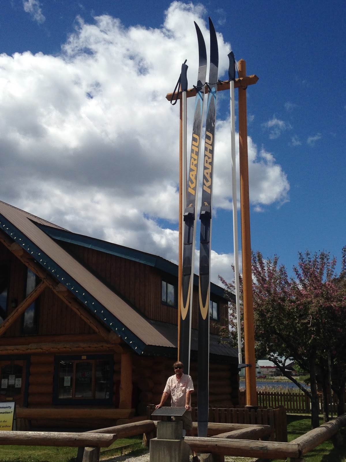
Me in front of the world's largest set of cross country skis (100 Mile House Visitor Center)

Who knew there was a desert in British Columbia? Complete with rattlesnakes.
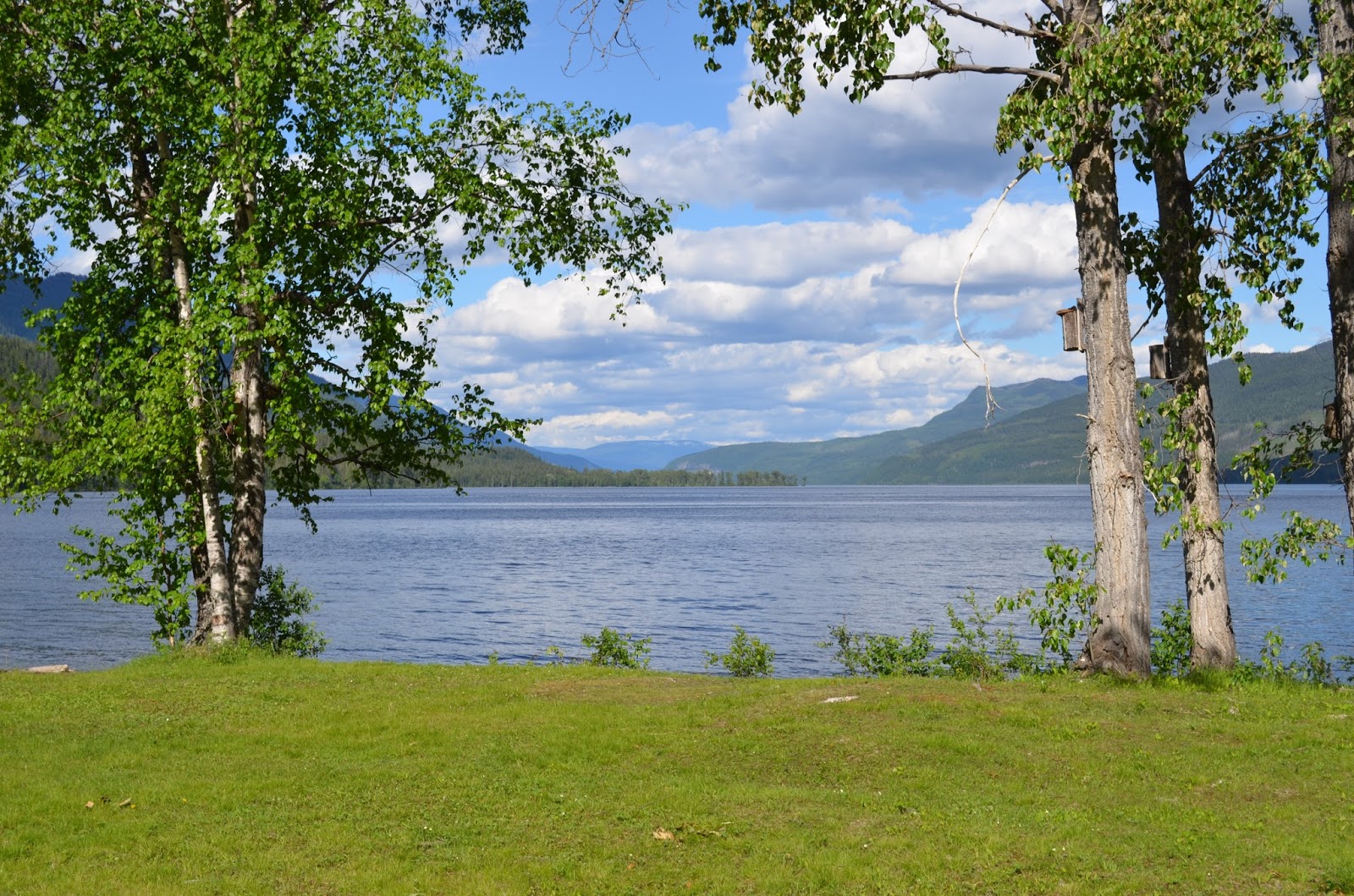
The view of Lake Mahood from our campsite at Wells Grey PP.

At Wells Grey PP

Duncan's reading skills aren't coming along like we hoped
Cinnamon Teal at Williams Lake 

Yellow Headed Blackbird at Williams Lake

Susan is still trying to figure out what this is

Red Wing Blackbird
American Widgeon (male)

Mother Hooded Merganser with her babies in close pursuit

Venturing out enough that you can count nine babies

Pair of American Widgeons

Williams Lake in Williams Lake, British Columbia
That's it for now. Take care.

Brian